

PARKEND BRIDGE AND CANNOP BROOK.
PARKEND BRIDGE.
The road passing along the front of the Fountain Inn dates back to at least 1670. In the 1700s it was used to transport timber to docks on the River Severn at Purton Passage and Gatcombe and so a substantial crossing was required where it met the Cannop Brook at Parkend.
Parkend Bridge is constructed entirely of stone and, viewed from underneath, it can be seen that the bridge is actually in three sections; having been widened at both its southern and northern arches. The original, central, section is exactly 14 feet wide. The northern extension is around half that, but the one on the southern side is much wider. The age of the central section is unknown, although certainly very old. It is assumed that the extended sections relate to the addition of the Milkwall Tramway and then, later, its repositioning to allow room for new a branch line that was added to the steam railway,

This 1776 map shows Parkend Bridge before it was widened. Interestingly, it spanned two watercourses; the main Cannop Brook and a smaller tributary which joins from the east. The tributary is thought to be a stream which once flowed off the hill, along the northern side of Yorkley Road. It was used as an outflow for a mine called Mason's Tump, and then later for water pumped out of Castlemain Pit too.
A tramway was built through Parkend in 1810 and, in 1812, a branch line to Milkwall was added. After leaving the mainline it crossed Parkend Bridge, before also crossing the road in front of the cottage that would go on to become the Fountain Inn.
This map, from Dibben's Survey of 1859, shows the tramway network as it existed at that time, with the bridge extended on its southern side. Maps of this age weren't always terribly accurate, but it does seem clear from this that the bridge's southern extension was added in 1812, presumably to avoid the tramway having to make a tight turn.
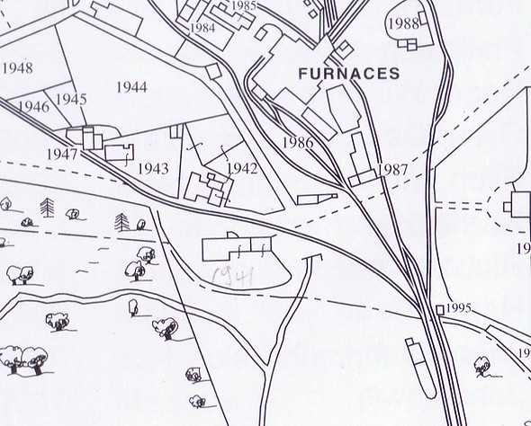
An exit portal for the smaller of the two streams, shown on the 1767 map, was built into this southern extension to the bridge and is still visible. We can conclude then, that its culverting, or at least this lower section, also took place at the same time.

In 1868 the tramway through Parkend was joined by a steam railway. In 1871 a branch line was added to the steam railway; connecting it to the newly built Marsh Wharf Sidings, via Parkend Bridge.
By this point, the tramway had been re-routed, and now approached from the north. It's not certain, but this may have been done to allow room for the new Marsh Wharf Sidings Branch Line; as the tramway's former position, on the southern side of the bridge, was now taken by the railway branch line.
This 1888 map shows the bridge now also extended on its northern side. It isn't certain, but it would seem then, that the northern extension to the bridge was added to accommodate the new line of the tramway in, or shortly before, 1871.
At some point this smaller stream was culverted along its entire length, although it can still be seen through a grill, where it passes under the road to Mount Pleasant
CANNOP BROOK.
Cannop Brook flows north to south through Parkend. Much of its route through the village is culverted, and out of sight, but after passing under Parkend Bridge it opens out to become a very attractive and natural-looking brook. It's easy to imagine it having existed there for thousands of years, but actually this isn't the case, and its present-day route through the woods behind the Fountain Inn is entirely artificial.
The land now occupied by the Dean Field Study Centre’s classrooms, was leased from the Office of Woods by Parkend Ironworks in 1836, and used by them to store cinders and clinker on. By 1848 the area was almost full and the ironworks approached the Office of Woods with a proposal to extend it by diverting Cannop Brook from a point immediately south of Parkend Bridge.
Their proposal was accepted and, in 1850, the river was diverted between Parkend Bridge and the bridge at Beaver Lodge. The new course cut through an area that had previously been used as a field, called Heath-Patch.
Diverting the river would not have been an easy task, as the ground level rises sharply between the two bridges, and the proposal noted that the cutting would need to be seven to eight feet deep in places.

In his book, The Story of Parkend, Ralph Anstis reports that some 12,000 tons of cinders and clinker were eventually removed from the tip to be used as ballast, and that the remainder was used to construct the Parkend to Whitecroft road in 1903. In 2012, however, the Dean Field Study Centre had some new classrooms erected on the site and it was discovered that an estimated several thousand tons of clinker still remain there.
The river's diverted route, south of Parkend Bridge, remains to the present day. On the north side of the bridge, some slight alterations to its course were made in 1995, as part of a flood alleviation scheme. The scheme included widening a culverted section in the centre of the village, and 'straightening' the river between there and Parkend Bridge; to increase its flow-rate.

Photos: Looking south, towards the Fountain Inn. Taken before the flood alleviation scheme, and showing how 'windy' the river's route used to be.
And, looking north, off Parkend Bridge, the river in the process of being straightened, as part of the flood alleviation works in 1995.
